Benchmark
Benchmark
This page frames fair comparison by navigation problem class — long-horizon, globally referenced position when GNSS and operator radio for navigation are denied. Illustrative figures and measured field results are labeled separately.
Comparison frame
Compares
- VIO, SLAM, IMU dead-reckoning, GNSS, and VIN as navigation classes under GNSS- and radio-denied assumptions.
- Failure modes on long-horizon missions: unbounded local drift vs map-backed global state.
- Whether a method maintains a persistent global reference without satellites or an operator nav link.
Does not compare here
- Named competitor marketing claims or bake-offs without a shared method.
- Local obstacle avoidance, mission AI, or perception stacks that are not global navigation.
- Price, BOM, or brand positioning.
Illustrative class comparison
Illustrative
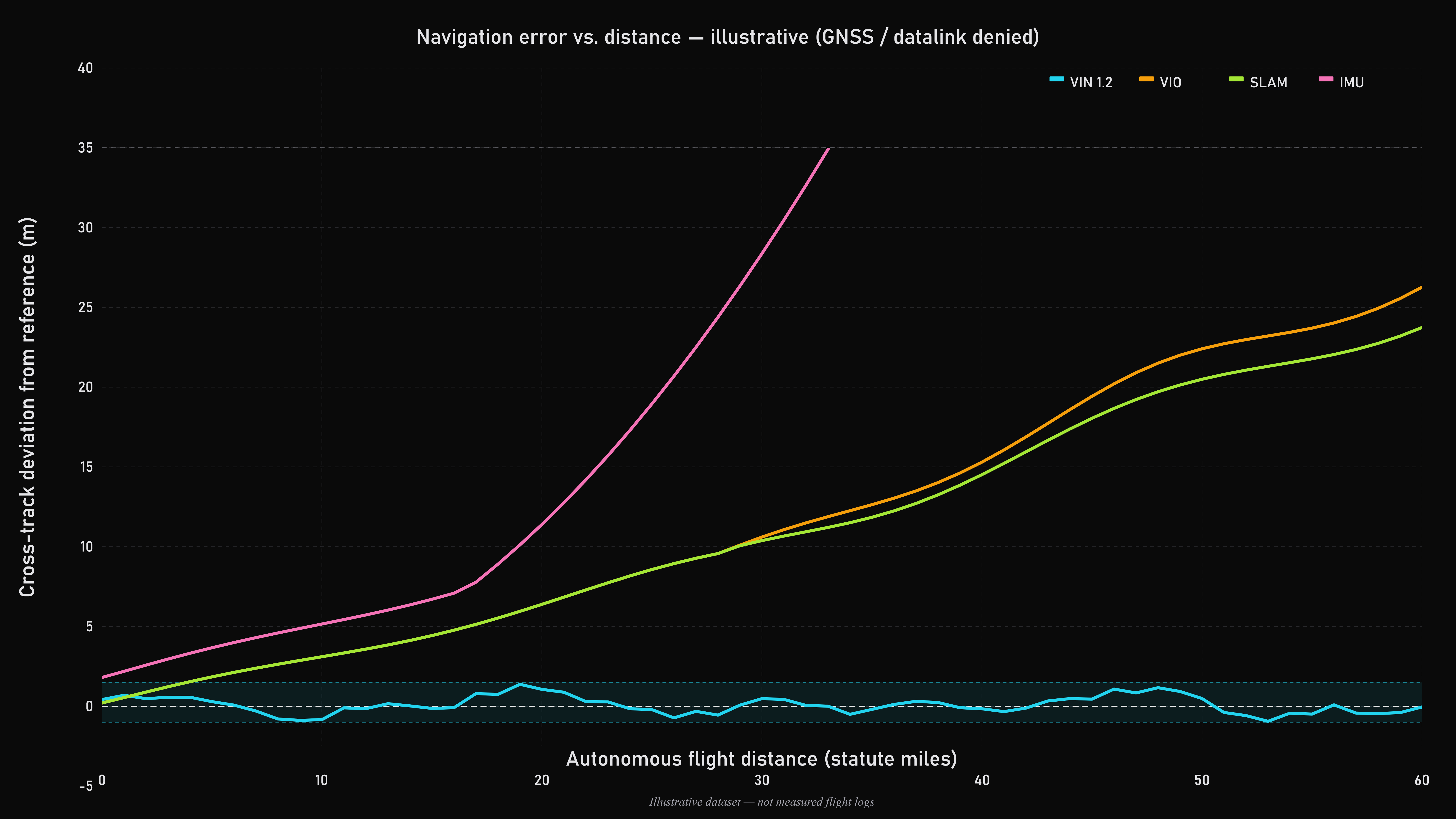
Illustrative deviation from the reference track (meters). VIN in the shaded corridor; generic VIO and SLAM track together then separate slightly; IMU dead-reckoning shows the largest error under GNSS and operator-datalink denial. This chart is the same public figure used on Visual Autonomy — it shows class behavior, not a substitute for measured field scoring.
Same chart on Visual Autonomy → · GNSS- and radio-denied framing →
Measured basis in this portal
Field scoring of VIN against a GNSS reference is published separately — method, sites, and scored sorties — not restated as a bake-off table here.
- Primary measured metrics: locked-mode horizontal error (median, mean, max) and vision lock duty-cycle.
- Current field sites: Ray Brickhouse Flying Field and Scobee Flying Field (AMA community, Texas).
- Full entries, video, and Excel reports: Flight Log. Snapshot and method: Independent Validation.
Fairness notes
- Same problem class and denial assumptions before any figure is read as a comparison.
- Illustrative charts are labeled Illustrative; measured sorties use the Validation / Flight Log method.
- Peer products often publish different metrics (local drift, obstacle performance, mission autonomy). Apples-to-apples comparison here is only on globally referenced navigation under denial.
- Independent third-party witness campaigns are not part of the present measured set; they will be reported when complete.
What this page describes — and what it does not
Describes
- Export-safe class framing for VIN vs VIO / SLAM / IMU / GNSS under denied conditions.
- The public illustrative navigation-error chart, reused here with the same Illustrative label.
- Pointers to measured field validation already published in this Briefing Center.
Does not include
- A full measured competitor pack — staged for L1 access when ready.
- Qualitative failure-mode table — Limitations of Existing Navigation.
- Architecture depth — Technology / vault materials under L1 access.
Independent Validation → · Limitations → · Technology → · Visual Autonomy (denied nav) →